New Delhi, Aug. 31 — India is expected to receive above-normal rainfall in September, capping a monsoon season already marked by extreme weather events, the India Meteorological Department (IMD) said Saturday.
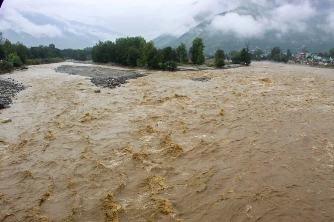
IMD Director General Mrutyunjay Mohapatra warned that heavy rains could trigger landslides and flash floods in Uttarakhand and disrupt normal life in south Haryana, Delhi, and north Rajasthan. “Many rivers originate in Uttarakhand. So, heavy rainfall means many rivers will be flooded and it will impact cities and towns downstream. We should keep this in mind,” he said.
Mohapatra also noted heavy rainfall in the upper catchment areas of the Mahanadi River in Chhattisgarh. Historical data show a slight increasing trend in September rainfall since 1980, except for drier years in 1986, 1991, 2001, 2004, 2010, 2015, and 2019.
The IMD projected that monthly average maximum temperatures will remain normal to below normal in west-central, northwest, and southern India during September, while temperatures are likely to be above normal in parts of east-central, east, northeast, northwest, and western coastal regions.
Between June 1 and August 31, India received 743.1 mm of rainfall, around 6% above the long-period average of 700.7 mm. June recorded 180 mm, 9% above normal; July 294.1 mm, 5% above normal; and August 268.1 mm, 5.2% above normal. Northwest India received 265 mm in August, the highest for the month since 2001, and cumulative rainfall for the season is 27% above normal. South Peninsular India also recorded above-average rainfall, with 31% surplus in August.
The unusually heavy rains coincided with extreme weather events across the country. Punjab faced its worst flooding in decades, while cloudbursts and flash floods caused landslides in Himachal Pradesh, Uttarakhand, and Jammu and Kashmir, leading to widespread damage and displacement.
The IMD attributed the surplus rain to active monsoon conditions supported by frequent western disturbances. Mohapatra said heavy rainfall between July 28 and August 14 over the western Himalayas and adjoining plains caused a flash flood and landslide in Uttarkashi on August 5 and major riverine floods in Uttar Pradesh and Bihar.
He added that the monsoon revived rapidly from August 14, with four low-pressure systems sustaining active conditions for 15 days in the second half of the month. Northwest India and adjoining western Himalayan states saw “extremely and exceptionally heavy rainfall events” between August 21 and 27, leading to floods in Punjab, Haryana, Jammu and Kashmir, and Rajasthan.
“These events were driven by the slow movement of two successive very active western disturbances, their interaction with remnants of monsoonal low-pressure systems, strong southerly winds bringing moisture from the Bay of Bengal and Arabian Sea, and formation of two low-pressure systems over the north Bay of Bengal moving across central India,” Mohapatra explained.